
Panoramic from top
This route had been on my to do list all summer. I’d seen the sweeping ramp in a book and several friends had mentioned it. I’d read mixed reports about the difficulty of the route. Some said 5.6 with an X rating and some no harder than 4th class and can be done in running shoes. From all I’d gathered I wanted to do it in a day (running, hiking and climbing) and I thought it might be my most ambitious solo outing yet.
During another break from work, I found myself in Silverton with a good weather forecast and encouragement from Jason who’d just done the route. I was hoping a partner from Durango would join but no word from him. I was a little intimidated by the route from the mixed reports and I knew it would be a big outing in the mountains to go solo. I figured this was my chance so I should just go for it and see how what happens.
I was well rested the day before and found a campsite at upper Molas Lake campground, a short drive to the trail head. However, in the morning I was confused as to where to start so I just started at Molas Pass on the Colorado Trail. This added full value points and a couple miles and a few hundred feet of climbing that I didn’t really need at the end of the day. Oh well, at least I got full value!
I had a modified big run breakfast of plain oatmeal and fruit and green tea instead of coffee. I’d been having problems with heart-burn in the mornings of long runs and I believe it is due to coffee. Everything was sitting well and I took off from the truck around 7 AM. One bombs down the Colorado trail, past groves of the poisonous red and white spotted amarita mushrooms, dew covered plants and a couple of hikers just getting going. I signed into the trail log and hoped I’d be signing out later that afternoon. And away I bombed down to the Animas river and Durango-Silverton narrow gauge railroad line. This was a pretty good warm up but I was dreading the climb out later.

Vestal Peak from the Colorado Trail
I didn’t know exactly where I was going but all my information was pretty straightforward and said stay on the Colorado Trail until Vestal Creek and then slog up to the peak. This seemed easy but I didn’t know exactly where the peak was much less the climbers trail. I spent a bit of time stopping and checking the map, looking for the peak and taking pictures. The peak is not visible for a long ways until just before the turn up the creek. But when Vestal Peak does come into view, it is obvious why it is one of Colorado’s classic scrambles. Wow! So striking from the Elk Creek Trail/CT. I get to a landmark I later read about, the beaver pond and figured I have to head over to the Vestal drainage from here. As I walked around a boulder by the pond, I startled upon some folks fishing. He didn’t know if the drainage went up to Vestal but said there was a trail and that he didn’t believe there were any fish in the pond! I figured it must be the trail so off I went, only about 2 hours in and a little over half way and a rough slog up the climbers trail awaited.
At least the trail was discernable, quite well worn actually. However, it did not allow for much running, just little spurts here and there until opening up into a meadow. The descent trail comes out in this meadow and this is where I prematurely crossed Vestal creek. Ideally one hikes all the way up to the lake but I crossed over thinking I’d find a trail and ended up bushwacking through dripping wet Manzanita bushes along bear trails until reaching the grassy rock slabs. From here I picked up a more use route and easily hike over to the far right side of the ridge.
I had packed climbing shoes but the ridge looked manageable in running shoes. I figured I’d just climb these shoes until sticky rubber edges of climbing shoes felt necessary. Up I went, navigating on the far right side of the face and ridge. The going wasn’t too technical but I could tell I hadn’t done any climbing like this in a while. The legs felt tired from the run and out of climbing shape. The scramble was fun enough to forget about fatigue though. I only encountered a few technical sections with some exposed crack jamming on the face and a bouldery layback corner that I decided to climb. The corner was the hardest part and probably could’ve been avoided by going back on the face but I had committed to the layback. It looked less exposed and straightforward until I got up the corner a ways. The foot holds kind of ran out near the top and my chosen route felt a little sketchier than upon first examination. After reversing my moves once and blocking out the unfortunate outcome of a fall, I knew I just had to make one move and then I could pull myself up.
I was past the hardest part now and I just had to route find up the easiest path. I started seeing some cairns and worn paths on the ledges at this point as the route trended back out right and went all over the place up loose but easy scrambling. I first hit a false summit that provided a nice view of the route I’d just climbed and again it looked improbable but amazing. The climb had gone much faster than expected but I was glad to take a long summit break.
The actual summit is across a saddle with more loose rock which is a sign of the descent. As most other reports mentioned, the descent o the south side is a maze of sketchy scree. This route required as much or more attention than the ridge scramble up. I reached the saddle between Arrowhead and Vestal and the descent continued down in the “endless” scree field. The route got steep, looser and larger rocks. Half way down, thunder boomed up canyon and I felt a few drops of rain. I looked up canyon in a slight bit of stress and exclaimed; “alright, alright, just let me get down to the trail so I can run before you start storming on me.” Nature headed to my call and scrambled down quickly, filling up my bottles with some fresh mountain stream water and hit the trail running.
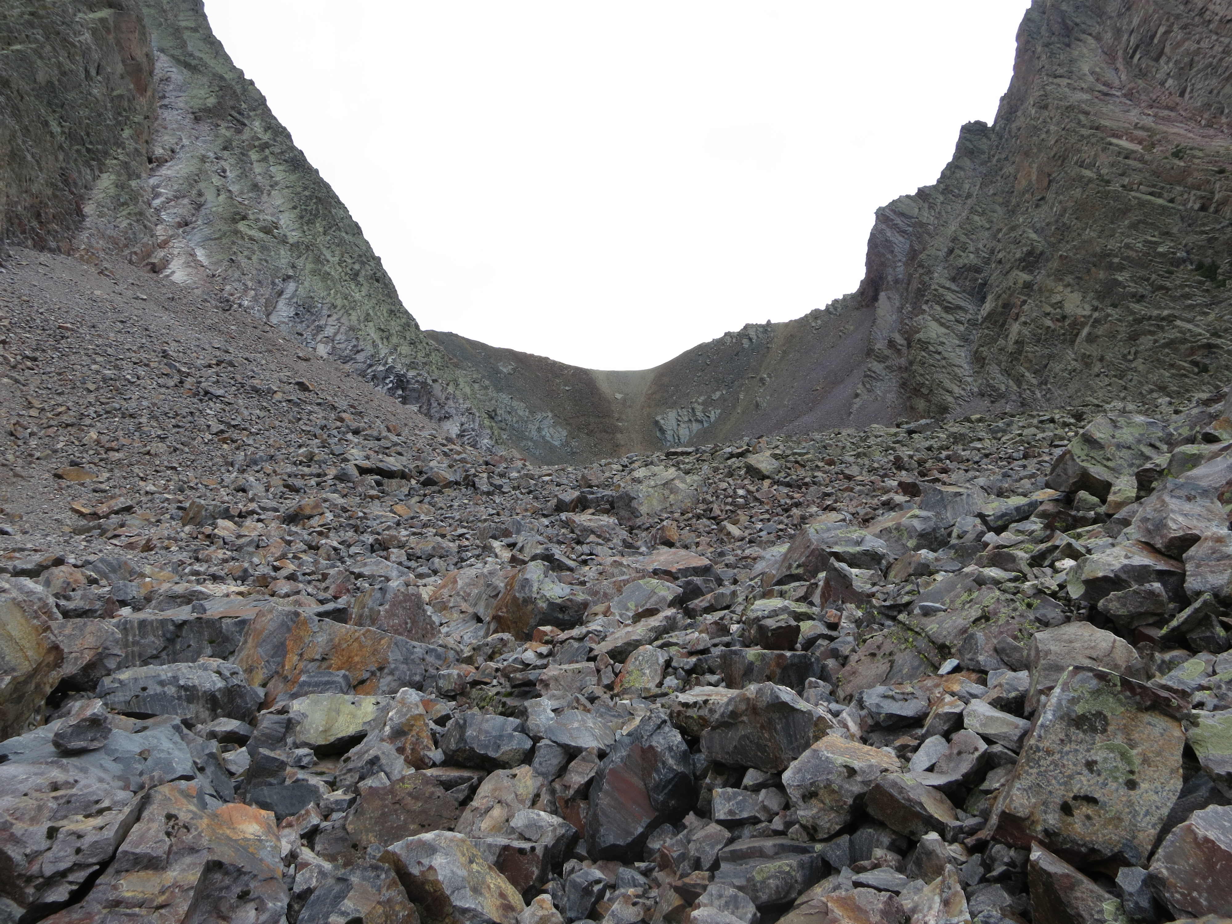
Endless scree field
I felt better than expected and ran most of the way back, even clocking in a negative split. I passed an older couple near the railroad trail split. The lady, who was only carrying a small backpack, exclaimed; “what are you doing in the middle of nowhere with no pack!” I did have a small pack and I just said I was heading back to the truck. The man, who was carrying a very large, near 60 lb pack with climbing helmet, etc. said nothing. I thought to myself, why are you out here carrying so much!
The climb back up the switchbacks was not as bad as I thought it’d be and ran a good bit of it. I thought I was near the truck when I passed the trail roster near Molas Lake, where I should’ve parked, but I still had a mile or two to go. I was not so proud of the full value at this point. Thinking I was close, I didn’t eat anything else. This caused me to bong harder than I can remember. I walked in the last bit and had to stop and eat a granola bar to alleviate the headache and dizziness. Yeah, the blood sugar was way low. The snack was a big helped and I walked on back to the car, still in good time. 9 hrs total and 8 hrs running time. This was about what I was shooting for.
I hadn’t felt this wrecked in quite a while but felt good to know I’d pushed myself to the limit, physically and mentally. Wham Ridge was easier than I anticipated but the whole outing was much more challenging than I thought. Looking forward to more mountain run/scrambles. The San Juans will have to wait until next summer but I have my eyes set on the Organ Mountains for the winter.
-

- Vast mountains
-

- Grenadier Range
-

- Trails
-

- First view of Vestal Peak
-

- View from Vestal Creek
-

- Another shot of Arrow Peak
-

- Vestal and Arrow
-

- Approach
-

- Vestal’s slopey ramp
-

- Start of Wham Ridge
-

- Arrow Peak
-

- Looking down at the start of the climb
-

- Vestal Peak Summit
-

- Trinities
-

- San Juans
-

- Summit shot
-

- Wham ridge from the scree field
-

- Steel trails
-

- This is the way
-

- View near Molas Lake
-

- Adventure gear: Montrail Bajada, Mountain Hardwear pack, Skinny Raven hat
